The United States has hundreds of thousands of miles of maintained hiking trails in it’s numerous National Park and Wilderness system. With spring here and summer right around the corner, it’s time to dust off our hiking boots and head outdoors.
Here’s our top 15 list of the best hikes in the US.
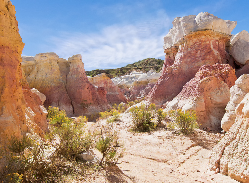
15.) Paint Mines, Calhan, Colorado
OLYMPUS DIGITAL CAMERA
The paint mines are geological formations in a valley near Calhan, in El Paso County. When the rock eroded over time, it left behind spires, caves and other formations that are white, yellow, orange and purple, in places.
The colorful rock was used by Native Americans for pottery and ceremonial paint, according to the park’s website. It says in the early 1900s, the clay was mined to make colorful bricks.
Take the flat, wide, dirt path out of the parking lot. Just a short distance from the parking lot, there’s a trail split. On a post it says, Formations 1.5 and it has an arrow to the right. Since we came to see the formations, we turned right. The trail climbs a short hill here. At the top is a bench and a view of the formations below.
14.) Cirque of the Towers, Wyoming
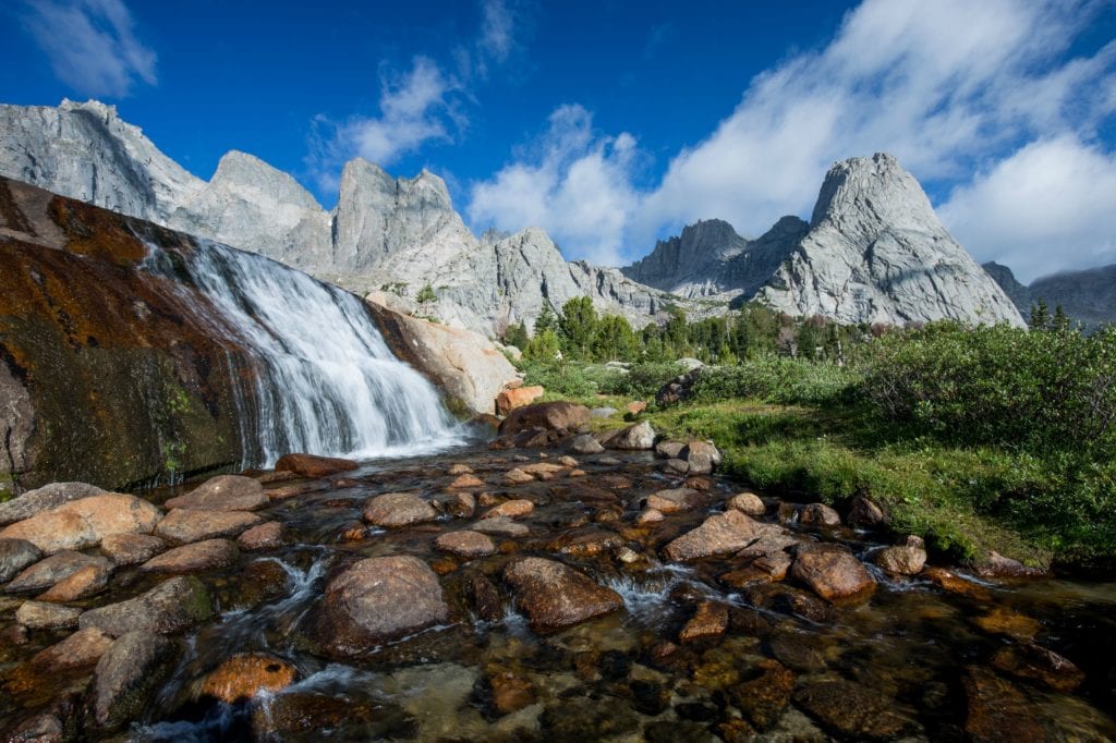
The Cirque is located in western Wyoming’s Rocky Mountains in the southern Wind River Range. There is no easy way to get to the trailhead and many consider the drive to the main trailhead to be the first crux of a Cirque of the Towers expedition. The drive can be a daunting task. The best map available which shows all the dirt roads is the Recreational Map of Wyoming published by GTR and is available here or in Rock Springs and Pinedale.
The most popular way into the Cirque is through the Big Sandy opening. Although the road is a fairly well-maintained dirt road, there is 30-40 miles of it (depending on the route), with sections of washboards which will rattle your teeth. In addition to personal experience, these directions and mileage are taken from a combination of three guide books.
Camping is available at the Big Sandy trailhead campground for $8.00/night from June 20 to September 10. There is no fee before or after those dates. There are 12 sites with pit toilets, no water and no showers. Most backpackers and fishermen camp closer to Lonesome Lake on the southern shores. With the bad water in the lake and the distance to the climbs, this is pointless for climbers. Better water and campsites for climbers are found in the rocky meadows of the western part of the Cirque directly south or southeast of Pingora. The stream from Hidden Lake directly below Warrior Peaks is a better source of water. Treat or filter all water in the Cirque. Bears are a problem both at Big Sandy Lake and in the Cirque.
13.) Mt. Healy Overlook Trial, Alaska
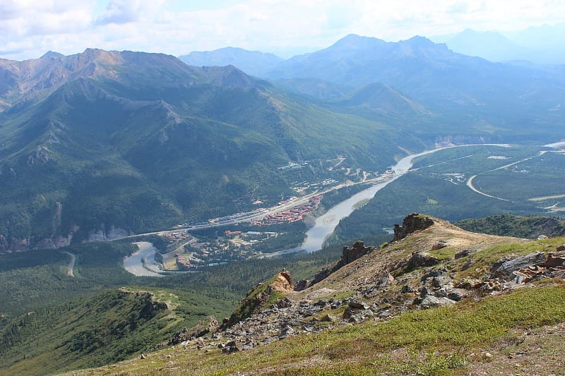
The first mile of this trail, which begins near the new Murie Science and Learning Center, is moderately steep, hiking through the forest. The forest eventually gives way to tundra. Trees turn to shrubs, and the landscape opens wide. The last 1.5 miles are even steeper. Your reward, however, is sweeping views of the Denali National Park entrance area, the Nenana River Valley, Healy Ridge, and nearby alpine ridges. Those who want to climb to the summit of Mount Healy should plan an all-day excursion.
The route is pretty steep the entire way, and the trail begins as a wide path that’s easy to see. Eventually, the trail drops in width to a single track as it approaches the treeline. Plenty of rocks and roots make for tougher going higher up too. The views in the last portion of the trail are spectacular as you’ll have made your way out of the thick forest that you began hiking under. As one of the steepest trails in the park, the journey up to the Mount Healy lookout is strenuous, but the view is worth it. It’s almost always windy up high, so come prepared. On a clear day you can see Denali.
12.) Many Glacier Area, Montana
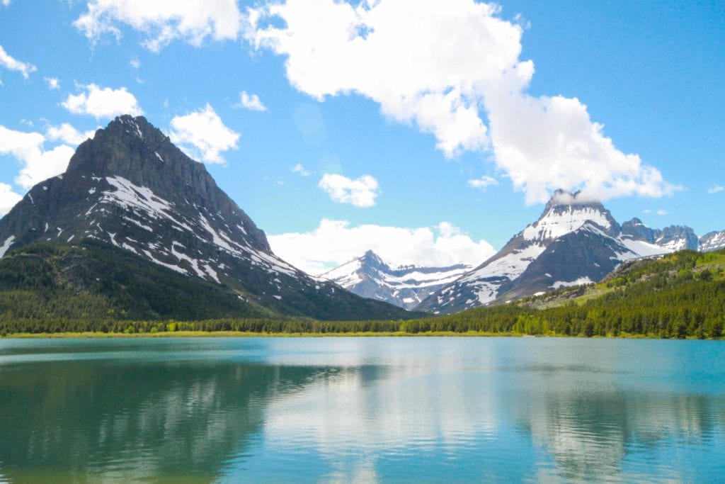
Many people consider this area the heart of the park. Massive mountains, active glaciers, sparkling lakes, hiking trails, and abundant wildlife make this a favorite of visitors and locals alike.
Many Glacier is also a destination where one can travel by car, foot, boat, or horseback, to get a close look at glaciers and see their impact on the landscape. The small glaciers seen today sculpt the land in much the same way as the larger ancient ice-age glaciers did; slowly grinding away on the mountains, carving rock and leaving a changed landscape. Many Glacier is a hikers paradise. Trails radiate out in all directions, including two of the most popular hikes in the park, the Grinnell Glacier trail and the Iceberg Lake trail.
Hikers can take a different trail every day for a week and still not cover all that the area has to offer. Springtime brings bighorn sheep close to the road and late summer is the best time to see bears, both grizzly and black, feasting on huckleberries on the slopes above the Swiftcurrent Motor Inn. Remember that all park wildlife can be dangerous; please keep your distance and never feed wildlife. If you don’t have a vehicle with you, take Glacier’s free shuttle to the St. Mary Visitor Center and hop on Glacier National Park Lodge’s fee-based shuttle to Many Glacier.
11.) Pisgah National Forest, Brevard, North Carolina
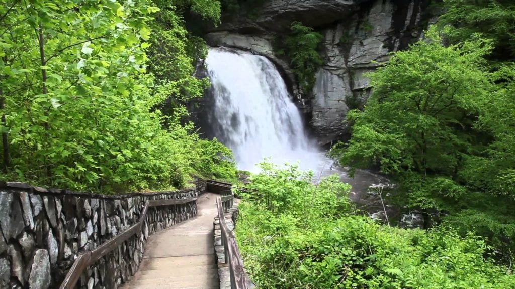
The Pisgah National Forest is a land of mile-high peaks, cascading waterfalls, and heavily forested slopes. Comprised of over 500,000 acres, the Pisgah is primarily a hardwood forest with whitewater rivers, waterfalls and hundreds of miles of trails. This national forest is home of the first tract of land purchased under the Weeks Act of 1911 which led to the creation of the national forests in the eastern United States. It is also home of the first school of forestry in the United States, now preserved at the Cradle of Forestry in America historic site, and boasts two of the first designated wilderness areas in the east.
The Pisgah, Grandfather and Appalachian Ranger Districts are scattered along the eastern edge of the mountains of western North Carolina and offer visitors a variety of opportunities for outdoor recreation and enjoying the natural beauty of the mountains.
Pisgah has so many waterfalls that many of them are not on the typical maps that you find out there. As your driving up, roll down your windows to hear the sound of rushing water. The park service has done a fantastic job of providing ‘pull offs’ along the road. These pull offs are not all for waterfalls, but many of them have beautiful views of the water cascading over the rocks. You may have to scramble down the embankments to get a better view.
10.) Arches National Park, Moab, Utah
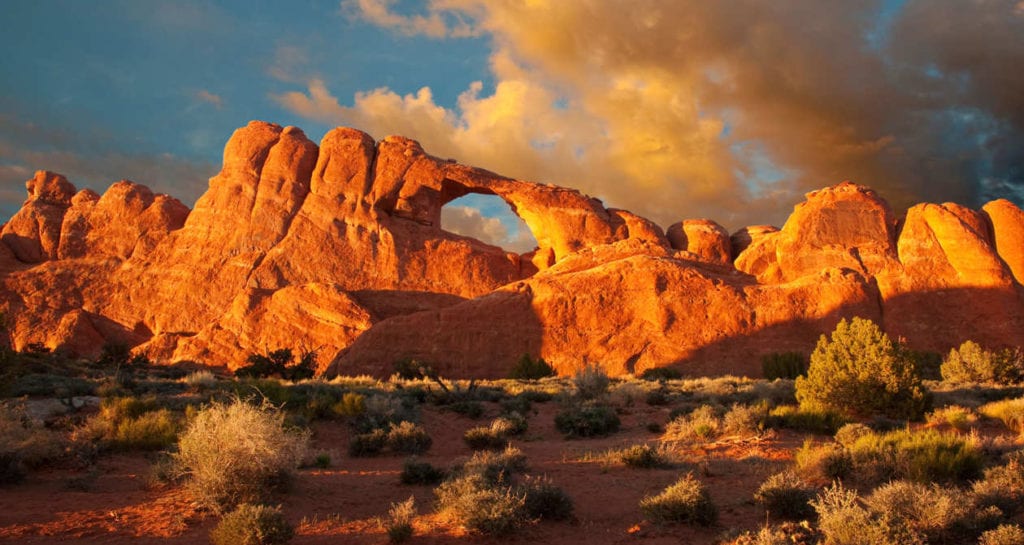
Arches National Park is a wonderland of red rocks and blue sky. The red rock landscape at Arches might feel timeless, dream-like, or even other-worldly. People have documented over 2,000 natural stone arches within park boundaries. You can see arches, towers, pinnacles, and balanced rocks from the paved park roads. Take a hike, and you can see even more.
Plan on spending at least a few hours in the park, exploring the scenic drive and several of the viewpoints and short trails. If time permits, longer hikes lead to many spectacular rock formations or consider attending a ranger-led program to learn more about this special place. Guided walks and/or evening programs occur daily, spring through fall.
Arches is part of the Colorado Plateau, a “high desert” region that experiences wide temperature fluctuations, sometimes over 40 degrees in a single day. The temperate (and most popular) seasons are spring (April-May) and fall (mid-September-October), when daytime highs average 60 degrees to 80 degrees and lows average 30 degrees to 50 degrees. Winters are cold, with highs averaging 30 degrees to 50 degrees, and lows averaging 0 to 20 degrees.
9.) Ewoldsen Trail, Julia Pfeiffer Burns State Park, Big Sur, California
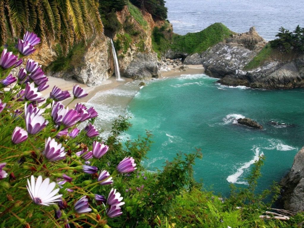
The park stretches from the Big Sur coastline into nearby 3,000-foot ridges. It features redwood, tan oak, madrone, chaparral, and an 80-foot waterfall that drops from granite cliffs into the ocean from the Overlook Trail. A panoramic view of the ocean and miles of rugged coastline is available from the higher elevations along the trails east of Highway 1.
In December and January the bench at the end of Overlook trail is an excellent place to watch for gray whales migrating southward to their breeding and calving grounds off the Baja California coast. Many whales pass close to shore at this point, and occasionally one will come into the mouth of the cove. In March and April, they can be seen returning north to their summer feeding grounds in the North Pacific.
Sea otters can sometimes be seen in the cove, and harbor seals and California sea lions are occasional visitors. Many sea and shorebirds – sleek black cormorants, seagulls, brown pelicans, and black oystercatchers also make an appearance.
The Ewoldsen Trail in Big Sur offers much of California’s diverse topography all in one hike. The trail takes travelers along the peaceful McWay Creek, through redwood groves and grassy valleys, as well as coastal mountaintops that offer picture-perfect views of the Pacific. The loop trail is a little more than a 5-mile round-trip journey and is touted by past visitors as one of the best day hikes in Big Sur. Before you go, however, make sure you know how to spot poison oak, as the plant is abundant in the area.
8.) Harding Icefield Trail, Kenai Fjords National Park, Alaska
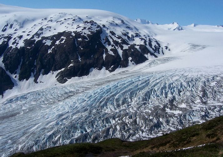
The 8.2-mile round trip Harding Icefield Trail is a spectacular day hike leaving from the Exit Glacier Area. Starting on the valley floor, the trail winds through cottonwood and alder forests, passes though heather filled meadows and ultimately climbs well above tree line to a breath-taking view of the Icefield.
Hikers gain approximately 1,000 feet of elevation with every mile. Allow at least 6-8 hours for the hike. Although the view from the top is well worth the effort, you need not hike all the way to the top to experience the wonders of this trail. Even a short hike up the trail affords impressive views of the valley floor and Exit Glacier’s terminus.
Check on trail conditions before starting out – the upper portion of the trail is often covered with snow through early July and there may be avalanche danger. Be prepared for storms, high winds, intense sunlight, and sudden temperature changes. Bring warm clothes, rain gear, sturdy footwear, sunglasses, and sunscreen. Carry plenty of water or bring along a filter – untreated water from streams along the trail may contain Giardia, a parasite that can cause severe abdominal distress. Stay on the trail. Alpine vegetation is extremely fragile.
Careless hikers who cut switchbacks, along with frequent summer rains, cause tremendous erosion. Volunteers help restore and maintain this trail every year. Please respect their hard work by sticking to the trail.
7.) Cadillac Mountain North Ridge Trail, Acadia National Park, Maine
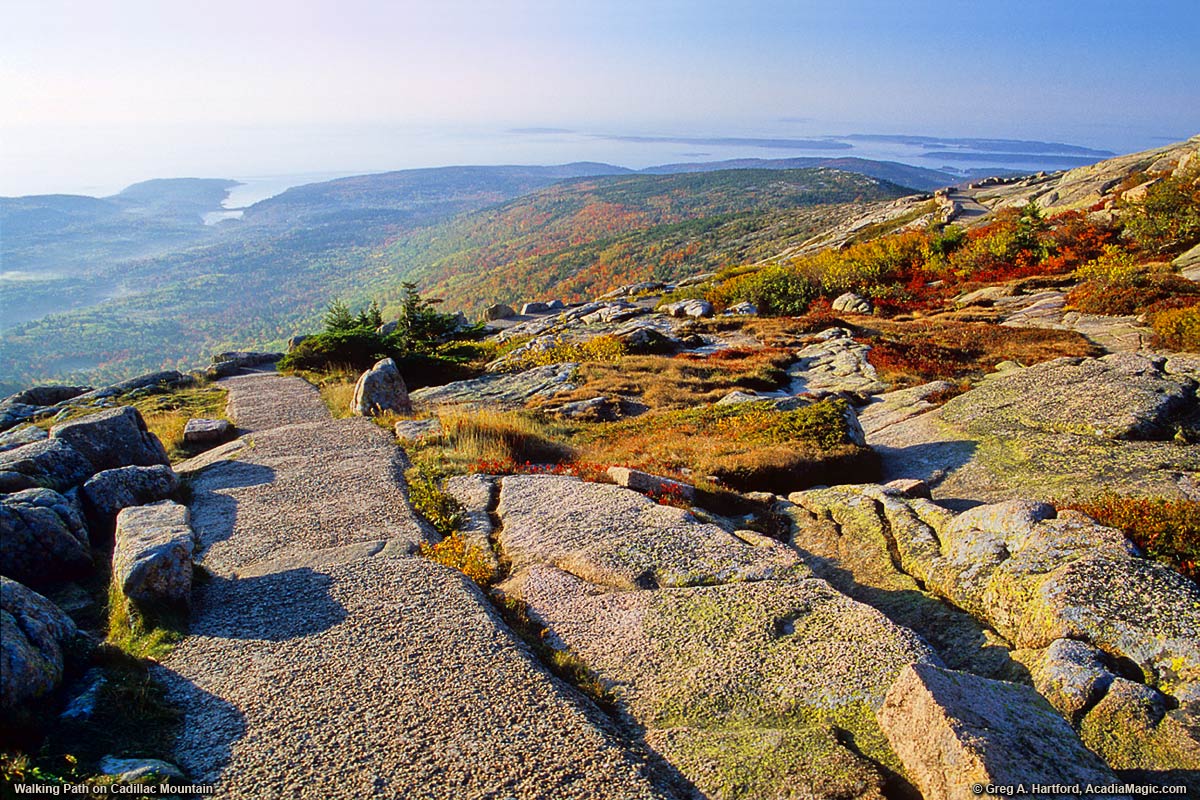
This is one of the most rewarding routes to the top of Cadillac Mountain, which at 1,528 feet is the tallest mountain in Acadia. The trailhead is located directly across from a small parking area on the left-hand side of the Park Loop Road. From the trailhead follow the blue blazes and rock cairns that mark the trail. Views of Bar Harbor will soon open up to the northeast. The higher you climb, the better the views become.
You’ll soon be treated to fantastic views of Frenchman Bay and the Porcupine Islands. In places the trail runs alongside a road so you’ll likely hear the sounds of passing cars. Thankfully, the final push to the summit is located away from the road, giving you plenty of peace and quiet. By this point you’ll have so many endorphins flowing through your brain that the crowds will hardly matter.
Cadillac Mountain is the tallest mountain on the North Atlantic seaboard, making it the star attraction of Acadia National Park. Although the striking summit can easily be accessed via Cadillac Mountain Road, the most rewarding way to experience the mountain’s magnificent vistas is on foot.
The Cadillac Mountain North Ridge Trail is a 4-mile round-trip journey that features a strenuous but manageable incline through lush green and granite landscapes. If you’re visiting from October to March, consider an early morning hike since Cadillac Mountain is the first point of the U.S. to greet the rising sun’s rays.
6.) South Kaibab Trail, Grand Canyon National Park, Arizona
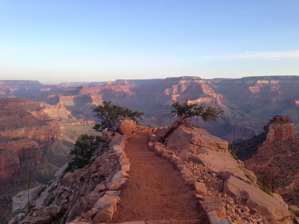
Hikers seeking panoramic views unparalleled on any other trail at Grand Canyon will want to consider a hike down the South Kaibab Trail. It is the only trail at Grand Canyon National Park that so dramatically holds true to a ridgeline descent. But this exhilarating sense of exposure to the vastness of the canyon comes at a cost: there is little shade and no water for the length of this trail. During winter months, the constant sun exposure is likely to keep most of the trail relatively free of ice and snow. For those who insist on hiking during summer months, which is not recommended in general, this trail is the quickest way to the bottom (it has been described as “a trail in a hurry to get to the river”), but due to lack of any water sources, ascending the trail can be a dangerous proposition.
5.) The Enchantments In Alpine Lake Wilderness, Washington
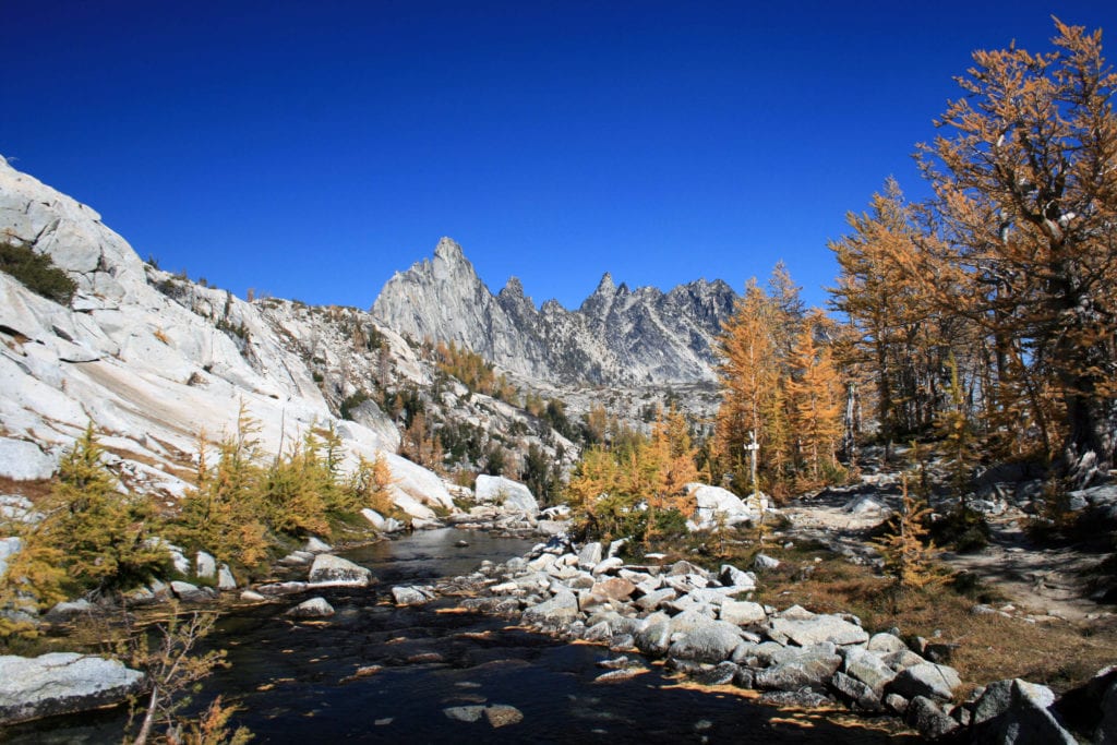 The Enchantments trail is a well-loved hike by Pacific Northwest residents. This hike takes a bit of pre-planning, patience and fortitude, but it is worth the time and effort. You’ll be rewarded with views of alpine lakes, granite spires, sweeping views and maybe a mountain goat or two. The views and vistas are what puts this hike on our list of the best hikes in the US.
This hike can be done as a through hike or an out and back and is best done over a few days. The trail is 18+ miles long with loads of options for exploring, hiking, scrambling and climbing. The trail is steady, rocky and steep and it’s best to start your ascent in the early morning.
The Enchantments trailhead is located just outside of Leavenworth, Washington. Leavenworth is a kitschy Bavarian-style town known for its Christmas festival. It is also a great place to camp before heading out on your hike. There is a KOA nearby that has all of the amenities you would want or need from a campsite. And there are also three breweries in town. Our favorite is Icicle Brewing Company. After a long hike, an icy cold pint of beer and charcuterie plate is heaven!
The Enchantments trail is open from about mid-July to mid-October. I think the best time of year to go is September, once the crowds have disappeared and the larches have started to turn their brilliant gold.
Know Before You Go: A permit is required. During peak season you must apply for your permit ahead of time on the recreation.gov site. This trail is not dog-friendly and is suitable for strong, experienced hikers.
4.) Alum Cave Trailhead To Mount LeConte In Great Smoky Mountains National Park, Tennessee
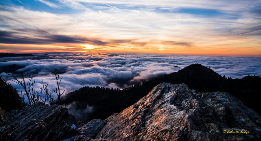
LeConte Lodge
Great Smoky Mountains National Park is the busiest national park in the United States. The park is lush with foliage, abundant biodiversity, rolling hills and over 700 miles of hiking trails. One of the best hikes in Great Smoky National Park is a 10 miler from Alum Cave Trailhead to Mount LeConte (and if you’re still feeling strong continue on to Myrtle Point for even more rewarding views).
The hike to Alum Cave is incredibly popular. If you would like to have the trail to yourself you should start early or go in the offseason. Beyond Alum Cave and Inspiration Point the crowds thin out a bit, even in high season.
The lower portion of the trail follows nearby cascading Alum Cave Creek and you’ll besurrounded by an old-growth forest of hemlock, rhododendron and yellow birch.
At Arch Rock you’ll find a naturally formed slate rock formation and a handful of steps with a cable handrail to head up to Alum Cave Bluff.
The trail picks up intensity after Alum Cave Bluff as you continue on to Mount LeConte. At the summit of Mt. LeConte there is a rustic lodge where you can stay the night, fill your water bottles, etc. LeConte Lodge, built in 1926, predates the establishment of the park.
If it’s possible, stay the night at the lodge (must book ahead) and catch sunrise from Myrtle Point. The Myrtle Point sunrise and the rich biodiversity of the trail are why the LeConte trail made it on our list of the best hikes in the US.
Before you go, grab a map like this one: Great Smoky Mountains Hiking Trail Map and plan to head out early.
3.) The Figure Eight Combination Trail In Bryce Canyon National Park, Utah
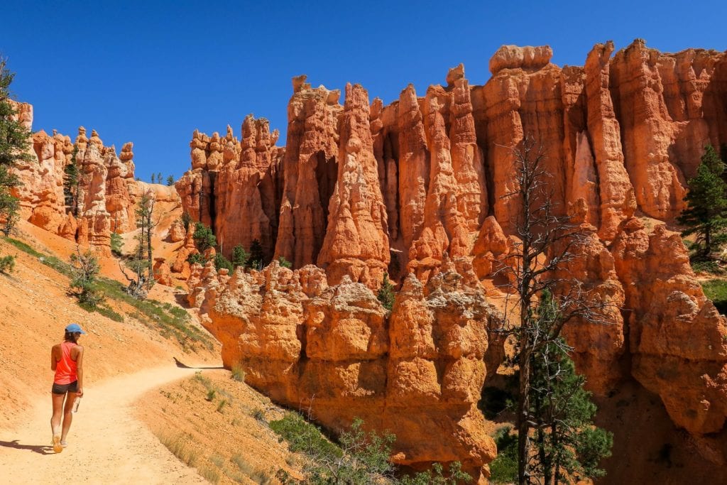
Loop together the Queen’s Garden/Navajo Loop with the Peek-a-boo trail for a 6.4 mile loop that takes in the parks wildest features. Bryce Canyon’s dramatic hoodoos and rock formations like Tower Bridge are what puts Bryce on our list of best hikes in the US.
The Queen’s Garden trail is an easier option for those short on time or are not feeling up to a longer hike. From the Queen’s Garden trail you’ll find Queen Victoria’s hoodoo, open vistas, the occasional pine tree for shade and really cool tunnels carved into the rocks.
The Navajo Loop section of the Figure Eight Trail is blessed with a series of heart pumping switchbacks. Bring plenty of water! On the Navajo Loop trail you will descend through towering mesmerizing hoodoos and find yourself in the shady, awe inspiring Wall Street.
And finally, you have the Peek-a-boo Trail, a strenuous trail that takes you away from the crowds of the park’s main trails. Here you will find a spur trail to Tower Bridge and more mesmerizing views of hoodoos minus the crowds. You will also see the Wall of Windows on this trail. A section of rocks that have been worn down over time and now allows for peek-a-boo views of Utah’s famous blue skies.
The park is quite busy during the summer months. If you plan on camping in the park then book ahead of time or you might end up in a “not so great” spot. In September, we were able to find a spot with relative ease, the trails weren’t as crowded, the weather was cool and crisp. In other words, it was perfect for hiking!
Know Before You Go: Reserve your camping spot early. No pets allowed. Pick up a trail map from park headquarters. Charge your camera and clear your memory card before you head out.
2.) The Narrows In Zion National Park, Utah
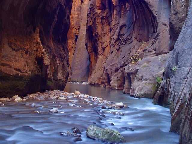
Zion National Park is one of the busiest national parks within the United States. Once you’ve experienced Zion you will fully understand why. The landscape is varied, it is steeped in history and the hikes are both stunning and unique. I had a hard time deciding between including either The Narrows or Angels Landing for this top five hiking list. I decided to include The Narrows instead of Angels Landing because The Narrows is an incredibly unique “hiking” experience.
The Narrows is best to hike in the summer months when the air and water are a bit warmer. The “trail” is up the Virgin River. The Virgin River has carved a stellar landscape into the earth here. At it’s narrowest point the gorge is only 20 feet wide and at it’s tallest point the walls soar up to 2000 feet!
As you hike deeper up the river the rock walls seem to undulate with overhangs and rocky outcroppings. The water from the river is cool and refreshing on a hot summer or fall day.
The trail can be done as a day hike out-and-back from the bottom of the canyon without a permit. If you want to hike the entirety of the river and camp within the canyon you must apply for a permit beforehand.
Know Before You Go: wear water shoes or Tevas, bring a sturdy hiking stick and a dry-bag to put your camera/electronics in. Water levels can change without warning. It is important to check the weather before departing on your hike. If rain is forecast, you should probably save this one for another day. The water in the early summer months is cold!
1.) Half Dome Via The Mist Trail In Yosemite National Park, California
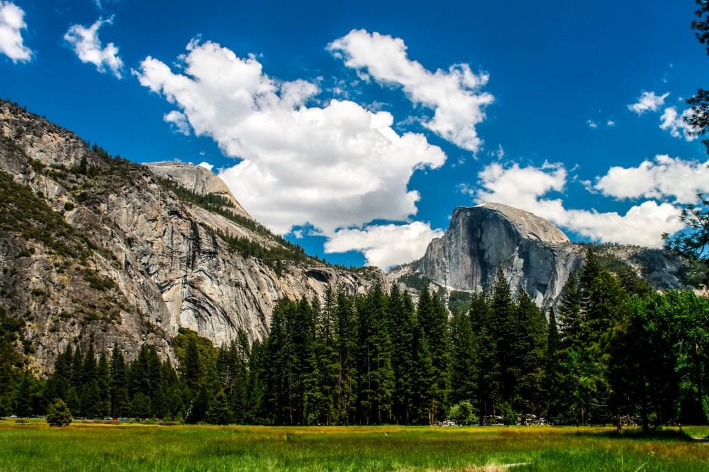
How do you choose the best hike in Yosemite National Park when they’re all amazing? You could spend an entire season hiking Yosemite’s trails. Half Dome is an iconic American hike and that’s why it made it to the number one spot of our Best Hikes in the US list. The Half Dome trail, with its near vertical “trail” is also one of the most dangerous hikes in the United States and it may not be the best option for someone afraid of heights.
The view from the top of Half Dome is as epic as they come with dramatic cliffs and the valley below. Almost every hiker who has hiked Half Dome will tell you it’s a once in a lifetime experience and worth the effort to make it to the top.
Luckily this 14 mile hike also passes by Vernal Falls and Nevada Falls. The falls could be a great place to turn around if you have children along with you. The falls are completely different from one another and are gorgeous in their own ways.
Know Before You Go: You must obtain a hiking permit to summit Half Dome. Wear sturdy shoes and bring plenty of water.